
-
Home
-
- About
- Administration
-
Govt. Offices
Agriculture & Food
-
Agriculture Extension Dept.
-
District Livestocs Office
-
District Veterinary Hospital, Nilphamari
-
Dist. Food Controller Office
-
District Fisheries Office
-
BADC (Seeds)
-
Barind Multipurpose Development Authority
-
Dept. of Agricultural Marketing
-
District Relief and Rehabilitation Office
-
DSCA
-
BADC (irrigation)
-
Department of Jute, Nilphamari
-
Bangladesh Food Safety Authority, District Office, Nilphamari
Engineering & Communication
-
Public Works
-
LGRD
-
Roads & Highways
-
Water Development Board
-
Education Engineering Dept.
-
Public Health Engineering Office
-
Nilphamari Palli Biddut Samity
-
Department of ICT
-
Dist. Information office
-
Employments and Human Resources
-
Northern Electricity Supply PLC
-
Bangladesh Rural Electrification Board
-
BTCL
Human Resources
-
Dept. of Social Service
-
City Social Services Office
-
Dept. of Youth Development
-
National Women Organization
-
Dept. of Women Affairs
-
BRDB
-
Cooperation Office
-
Disability Service and Help Center
-
Islamic Foundation
-
Hindu Religion welfare Trust
-
হাসপাতাল সমাজসেবা কার্যালয়, নীলফামারী
-
Youth Training Center, Nilphamari
-
Office of the Probation Officer, Nilphamari
-
Government Children Family(Boys), Nilphamari
-
Agriculture Extension Dept.
- Local Government
- Other Institutions
- e-Services
- Gallery
- National Anthem
- Hemoglobin
-
Home
-
-
About
Introduce to the District
History-Tradition
Geographic and Economic
Others
-
Administration
□ Deputy Commissioner
Deputy Commissioner\'s Office
Additional Deputy Commissioners
Officers and Employees
Branch related
Resolutions of Meeting
Important information
-
Govt. Offices
Security & Discipline Affairs
Education & Culture
Health
Agriculture & Food
- Agriculture Extension Dept.
- District Livestocs Office
- District Veterinary Hospital, Nilphamari
- Dist. Food Controller Office
- District Fisheries Office
- BADC (Seeds)
- Barind Multipurpose Development Authority
- Dept. of Agricultural Marketing
- District Relief and Rehabilitation Office
- DSCA
- BADC (irrigation)
- Department of Jute, Nilphamari
- Bangladesh Food Safety Authority, District Office, Nilphamari
Engineering & Communication
- Public Works
- LGRD
- Roads & Highways
- Water Development Board
- Education Engineering Dept.
- Public Health Engineering Office
- Nilphamari Palli Biddut Samity
- Department of ICT
- Dist. Information office
- Employments and Human Resources
- Northern Electricity Supply PLC
- Bangladesh Rural Electrification Board
- BTCL
Human Resources
- Dept. of Social Service
- City Social Services Office
- Dept. of Youth Development
- National Women Organization
- Dept. of Women Affairs
- BRDB
- Cooperation Office
- Disability Service and Help Center
- Islamic Foundation
- Hindu Religion welfare Trust
- হাসপাতাল সমাজসেবা কার্যালয়, নীলফামারী
- Youth Training Center, Nilphamari
- Office of the Probation Officer, Nilphamari
- Government Children Family(Boys), Nilphamari
Land and Revenue Realted
More ...
-
Local Government
District Council
Upazila Council
Union Council
-
Other Institutions
Educational Institutions
Organizations
Religious Institutions
-
e-Services
e-Services
e-Services
-
Gallery
Photo Gallery
Videos Gallery
-
National Anthem
National Anthem (Audio)
National Anthem (Music Track)
National Anthem (Text)
-
Hemoglobin
Hemoglobin
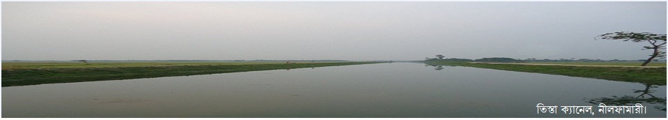
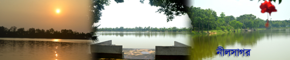
Located approximately 400 kilometers northwest of the capital, Dhaka, Nilphamari District covers an area of 1,821 square kilometers and is situated just north of the Tropic of Cancer. It is bordered by Rangpur and Lalmonirhat districts to the east, Rangpur and Dinajpur to the south, Dinajpur and Panchagarh to the west, and India's Siliguri district to the north. About 90% of the district’s simple and hardworking population is engaged in agriculture in some form. The vast, flat lands of Nilphamari yield abundant harvests of rice, wheat, potatoes, tobacco, and a variety of other crops each year. Nilphamari is the birthplace of several distinguished individuals, including artist Haralal Roy, Mahesh Chandra Roy, and Rathindra Nath Roy. The Teesta Irrigation Project, the largest of its kind in the country, plays a crucial role in boosting agricultural production by providing extensive irrigation and supplementary irrigation facilities. However, the Teesta River, flowing through the northeastern part of the district, continues to pose challenges, particularly for the upazilas of Dimla and Jaldhaka, where seasonal flooding remains a persistent issue. Strategically located at the heart of the greater Rangpur-Dinajpur region, Nilphamari’s Syedpur area is a major contributor to the national economy through its vibrant small-scale industries. Syedpur is also home to the country's largest railway workshop, further underscoring its industrial significance. In addition, the Uttara Export Processing Zone (EPZ) has been playing a leading role in generating employment and earning foreign currency. The vast Nilsagar lake stands as one of the district’s key tourist attractions. The recently launched Nil Sagar Intercity Express train service has further enhanced connectivity, contributing significantly to the region’s communication infrastructure.
| Sl. No. | Category | Details |
|---|---|---|
| 01 | Area
|
1,643.40 sq. km |
| 02 | Geographical Location
|
25°44′ to 26°19′ N, 88°46′ E |
| 03 |
Population (2022) |
Total: 2,092,568
Male: 1,041,802 Female: 1,050,712 Hijra: 54 |
| 04 |
Population Density |
1,274 per sq. km |
| 05 |
Occupation |
Farmer: 45.28%, Agri. Laborer: 27.81%, Day Laborer: 3.42%, Business: 8.65%, Service: 6.07%, Others: 8.77% |
| 06 |
Religion |
Muslim: 84.29%, Hindu: 15.66%, Christian: 0.05%, Buddhist: 0.02%, Others: 0.004% |
| 07 |
Parliamentary Seats |
4 |
| 08 |
Upazilas |
6 (Nilphamari Sadar, Saidpur, Domar, Dimla, Jaldhaka, Kishoreganj) |
| 09 |
Municipalities |
4 (Nilphamari Sadar, Saidpur, Domar, Jaldhaka) |
| 10 |
Unions |
60 |
| 11 |
Mouzas |
370 |
| 12 |
Villages |
378 |
| 13 |
Border with India |
50.90 km |
| 14 |
BOPs |
11 |
| 15 |
Total Land |
158,577.77 hectares |
| 16 |
Arable Land |
126,133 hectares |
| 17 |
Irrigated Land |
114,000 hectares |
| 18 |
Forest Area |
1,346.15 acres |
| 19 |
Wetland Area |
1,109.03 acres |
| 20 |
Urban Area |
96.561 sq. km (Nilphamari: 24.50, Jaldhaka: 28.22, Domar: 9.421, Saidpur: 34.42) |
| 21 |
Food Surplus |
285,906 metric tons |
| 22 |
Hospitals |
9 |
| 23 |
Diabetic Clinics |
2 |
| 24 |
Maternal & Child Welfare Centers |
2 |
| 25 |
Family Welfare Centers |
55 |
| 26 |
Primary Schools |
940 (Govt: 472, Private: 439, Community: 29) |
| 27 |
Secondary Schools |
295 (Govt: 5, Private: 192, Junior: 98) |
| 28 |
Colleges |
45 (Govt: 4, Private: 41) |
| 29 |
Technical Training Centers |
19 (Govt: 2, Private: 17) |
| 30 |
PTI |
1 |
| 31 |
Madrasahs |
164 (Kamil: 1, Fazil: 14, Alim: 24, Dakhil: 115) |
| 32 |
Literacy Rate |
69.23% (2022) |
| 33 |
Paved Roads |
470 km |
| 34 |
Unpaved Roads |
3,592 km |
| 35 |
Railway Stations |
9 |
| 36 |
Railway Tracks |
63 km |
| 37 |
Railway Workshop |
1 |
| 38 |
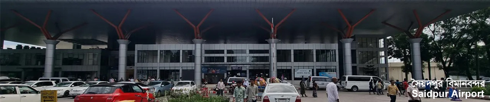
Airport |
1 |
| 39 |
Public Libraries |
6 |
| 40 |
Religious Institutions |
Mosques: 2,514, Temples: 371, Churches: 2 |
| 41 |
Registered NGOs |
28 |
| 42 |
Orphanages |
8 |
| 43 |
Fire Stations |
3 |
| 44 |
Cold Storages |
6 |
| 45 |
Food Warehouses |
34 (LSD: 7) |
| 46 |
Markets & Bazaars |
98 |
| 47 |
Post Offices |
107 |
| 48 |
Cantonment |
1 |
| 49 | Tourist Attractions
|
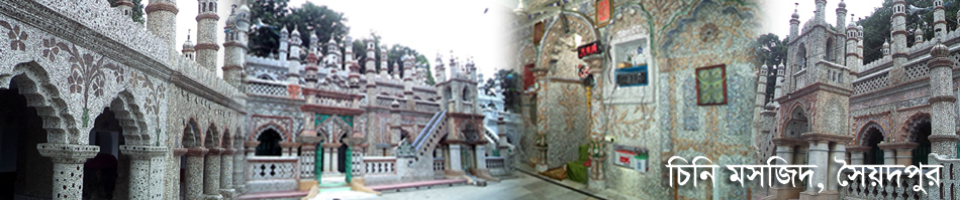
Nil Sagar, Harishchandra’s Path, Dharmapal’s Fort, Kundapukur Mazar, Moynamoti Fort, Bhimer Mayer Chula |
| 50 |
Union Land Offices |
60 |
| 51 |
Municipal Land Offices |
3 |
| 52 |
Major Rivers |
Teesta, Buriteesta, Burikhora, Charalkata, Deonai, Bamandanga |
| 53 |
Teesta Canal Length |
1,004 km |
| 54 |
Ashrayan Projects |
7 |
| 55 |
Ideal Villages |
42 |
| 56 |
Families Rehabilitated |
1,090 |
| 57 |
Red Crescent |
1 |
| 58 |
Shilpakala Academy |
1 |
| 59 |
Chamber of Commerce |
1 |


Planning and Implementation: Cabinet Division, A2I, BCC, DoICT and BASIS
Technical Assistance:
![]()
Developed By:
